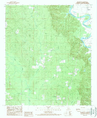
1989 Map of Blankston
USGS Topo · Published 1989About this map
The Ouachita River meanders through the northeast corner of this 1980s landscape, shaping a terrain defined by complex drainage networks and low-lying wetlands. The settlement of Blankston sits along the river's edge, served by a small riverside Cem, while Mt Pleasant occupies higher ground to the south. The area is heavily marked by intricate watercourses, including the lengthy Castor Creek, Bills Creek, and Richland Creek, which carve through the wooded landscape toward the river basin.
Find a feature on this map
11 named features on this map. Tap any name to fly to it.
Don’t see what you’re looking for? This feature index may not catch every label — zoom into the map to look around manually.
Map Details
Editions of this 1989 Blankston Map
This is the sole edition of this map. No revisions or reprints were ever made.
Other maps of this area

1940 · Monroe
USGS Topo · 1:62,500

1940 · Columbia
USGS Topo · 1:62,500

1953 · Chatham
USGS Topo · 1:62,500

1954 · Sikes
USGS Topo · 1:62,500

1955 · Shreveport
USGS Topo · 1:250,000

1956 · Shreveport
USGS Topo · 1:250,000

1957 · Columbia
USGS Topo · 1:62,500

1957 · Monroe South
USGS Topo · 1:62,500

1982 · Chatham SE
USGS Topo · 1:24,000
1982 · Luna
USGS Topo · 1:24,000