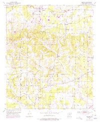
1951 Map of Blevins
USGS Topo · Published 1978About this map
The town of Blevins serves as the focal point of this Hempstead County survey, depicting the community and its outlying rural settlements during the mid-twentieth century. The landscape is characterized by a dense network of local landmarks, including the Blevins Training Sch and Shorter Ch, which highlight the educational and religious infrastructure of the era. The mapping reveals a pattern of dispersed homesteads and small gathering places like Dunlap and Deaneyville, connected by a web of winding country roads that follow the ridges between the numerous creek branches.
Find a feature on this map
35 named features on this map. Tap any name to fly to it.
Don’t see what you’re looking for? This feature index may not catch every label — zoom into the map to look around manually.
Map Details
Editions of this 1951 Blevins Map
4 editions found
Other maps of this area

1901 · Gurdon
USGS Topo · 1:125,000

1951 · Blevins
USGS Topo · 1:24,000

1951 · Sheppard
USGS Topo · 1:24,000

1951 · Washington
USGS Topo · 1:24,000

1951 · Pisgah
USGS Topo · 1:24,000

1951 · Hope
USGS Topo · 1:24,000

1951 · McCaskill
USGS Topo · 1:24,000

1953 · El Dorado
USGS Topo · 1:250,000

1957 · El Dorado
USGS Topo · 1:250,000

1958 · El Dorado
USGS Topo · 1:250,000