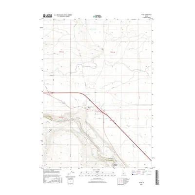
2017 Map of Bliss
USGS Topo · Published 2017About this map
Bliss sits at a critical geographic junction where the high desert plateau meets the deep canyon of the Snake River. This 2017 survey details a landscape defined by its complex irrigation infrastructure, including the King-Hill-Main Canal, Y Canal, and Z Canal, alongside numerous laterals that sustain agriculture above the Hagerman Valley. The descent from the town toward the river is marked by the winding Bliss Grade Rd, leading toward the Bliss Reservoir where the Gooding Co and Twin Falls Co border follows the river's course. Transportation patterns are clearly visible, contrasting the modern interstate corridor with the alignment of Old Highway 30 and rural routes like Hill City Rd. The map provides a precise view of how water management and topography dictate the settlement patterns of this Idaho region.
Find a feature on this map
34 named features on this map. Tap any name to fly to it.
Don’t see what you’re looking for? This feature index may not catch every label — zoom into the map to look around manually.
Map Details
Editions of this 2017 Bliss Map
This is the sole edition of this map. No revisions or reprints were ever made.
Other maps of this area

1892 · Camas Prairie
USGS Topo · 1:125,000

1893 · Camas Prairie
USGS Topo · 1:125,000

1948 · Ticeska
USGS Topo · 1:24,000

1949 · Ticeska
USGS Topo · 1:24,000

1949 · Pasadena Valley
USGS Topo · 1:62,500

1949 · Bliss
USGS Topo · 1:24,000

1949 · Gooding Butte
USGS Topo · 1:24,000

1949 · Tuttle
USGS Topo · 1:24,000

1949 · Hagerman
USGS Topo · 1:24,000

1949 · Indian Butte
USGS Topo · 1:24,000