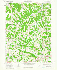
1962 Map of Bloomfield
USGS Topo · Published 1963About this map
The rolling hills of Muskingum and Guernsey counties are defined here by a mix of educational landmarks and resource extraction in the early 1960s. Muskingum College and the John H Glenn High Sch anchor the southwestern corner near New Concord, while the surrounding landscape is marked by a network of energy infrastructure, including numerous Gas Wells and a prominent Pipeline. The northeastern corner is dominated by the waters of the Wills Creek Reservoir, which disrupts the standard drainage patterns of Indian Camp Run and Dry Run.
Find a feature on this map
45 named features on this map. Tap any name to fly to it.
Don’t see what you’re looking for? This feature index may not catch every label — zoom into the map to look around manually.
Map Details
Editions of this 1962 Bloomfield Map
4 editions found
Other maps of this area

1908 · Conesville
USGS Topo · 1:62,500

1909 · Cambridge
USGS Topo · 1:62,500

1910 · Philo
USGS Topo · 1:62,500

1910 · Conesville
USGS Topo · 1:62,500

1911 · Cumberland
USGS Topo · 1:62,500

1912 · Cambridge
USGS Topo · 1:62,500

1949 · Clarksburg
USGS Topo · 1:250,000

1951 · Canton
USGS Topo · 1:250,000

1953 · Canton
USGS Topo · 1:250,000

1956 · Clarksburg
USGS Topo · 1:250,000