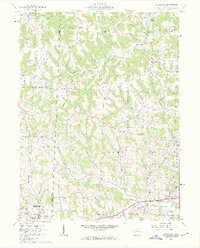
1962 Map of Bloomfield
USGS Topo · Published 1963About this map
The boundary between Muskingum and Guernsey counties defines this landscape of deeply dissected ridges and creek valleys during the early 1960s. Education and local civic life center on the southwestern corner near New Concord, where the grounds of Muskingum College and the John H Glenn High Sch are established landmarks. To the north, the terrain rises toward the Twin Sister Knobs and the Bloomfield Lookout Tower, overlooking a network of narrow runs such as Indian Camp Run and Sarchett Run.
Find a feature on this map
41 named features on this map. Tap any name to fly to it.
Don’t see what you’re looking for? This feature index may not catch every label — zoom into the map to look around manually.
Map Details
Editions of this 1962 Bloomfield Map
4 editions found
Other maps of this area

1908 · Conesville
USGS Topo · 1:62,500

1909 · Cambridge
USGS Topo · 1:62,500

1910 · Philo
USGS Topo · 1:62,500

1910 · Conesville
USGS Topo · 1:62,500

1911 · Cumberland
USGS Topo · 1:62,500

1912 · Cambridge
USGS Topo · 1:62,500

1949 · Clarksburg
USGS Topo · 1:250,000

1951 · Canton
USGS Topo · 1:250,000

1953 · Canton
USGS Topo · 1:250,000

1956 · Clarksburg
USGS Topo · 1:250,000