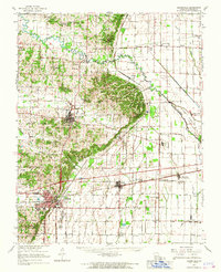
1963 Map of Bloomfield
USGS Topo · Published 1967About this map
Dexter and Bloomfield serve as the primary hubs in this early 1960s portrait of Stoddard County, where the transition from higher ground to the alluvial lowlands of the Bootheel is starkly visible. The Castor River meanders through the northeast, while an extensive drainage network, including the Dudley Ditch, reveals the massive engineering effort required to reclaim this land for agriculture. This rural landscape is densely punctuated by country churches and small rural schools that defined community life, such as St Joe Ch, Olive Branch Ch, and South Richland Sch.
Find a feature on this map
59 named features on this map. Tap any name to fly to it.
Don’t see what you’re looking for? This feature index may not catch every label — zoom into the map to look around manually.
Map Details
Editions of this 1963 Bloomfield Map
This is the sole edition of this map. No revisions or reprints were ever made.
Other maps of this area

1931 · Sikeston
USGS Topo · 1:62,500

1934 · Morley
USGS Topo · 1:62,500

1934 · Bloomfield
USGS Topo · 1:62,500

1934 · Sikeston
USGS Topo · 1:62,500

1934 · Advance
USGS Topo · 1:62,500

1934 · Puxico
USGS Topo · 1:62,500

1935 · Zalma
USGS Topo · 1:62,500

1939 · Bloomfield
USGS Topo · 1:62,500

1939 · Sikeston
USGS Topo · 1:62,500

1939 · New Madrid
USGS Topo · 1:62,500