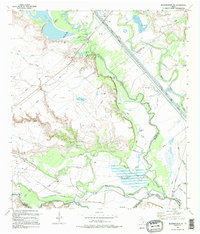
1995 Map of Bloomington SW
USGS Topo · Published 1995About this map
The Guadalupe River and San Antonio River converge in this low-lying coastal plain, creating a complex network of bayous and wetlands where Victoria, Calhoun, and Refugio counties meet. This 1995 revision of mid-century surveys documents a landscape heavily influenced by both natural hydrology and industrial water management. The straight line of the Barge Canal (Private) cuts across the natural meanders of the river systems, flanked by a Pumping Sta and various levees. Genealogical interest is centered on small, remote burial sites such as Nolan Cem and Rudolph Cem, which persist among the numerous gas wells and oil fields that dot the terrain. The map tracks the winding paths of Cushman Bayou and Swift Bayou as they drain into the larger river basins, alongside named water bodies like Linn Lake and Alligator Lake.
Find a feature on this map
26 named features on this map. Tap any name to fly to it.
Don’t see what you’re looking for? This feature index may not catch every label — zoom into the map to look around manually.
Map Details
Editions of this 1995 Bloomington SW Map
This is the sole edition of this map. No revisions or reprints were ever made.
Other maps of this area

1951 · Bloomington
USGS Topo · 1:24,000

1952 · Tivoli
USGS Topo · 1:24,000

1952 · Bloomington SW
USGS Topo · 1:24,000

1952 · Austwell
USGS Topo · 1:24,000

1952 · Placedo
USGS Topo · 1:24,000

1952 · Green Lake
USGS Topo · 1:24,000

1953 · Beeville
USGS Topo · 1:250,000

1954 · Vidaurri
USGS Topo · 1:62,500

1956 · Beeville
USGS Topo · 1:250,000

1960 · Beeville
USGS Topo · 1:250,000