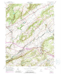
1955 Map of Bloomsbury
USGS Topo · Published 1988About this map
Pohatcong Mountain and Scotts Mountain dominate this mid-century New Jersey landscape, which is defined by the industrious corridors of the Musconetcong River and Pohatcong Creek. The era's transportation network is remarkably dense, featuring the traces of the Morris Canal alongside major rail lines like the Lackawanna RR and the Lehigh Valley RR. These routes connected established settlements such as Stewartsville, Bloomsbury, and Asbury, while smaller locales like Lows Hollow and New Village reveal the finer grain of historical development in Warren and Hunterdon counties.
Find a feature on this map
51 named features on this map. Tap any name to fly to it.
Don’t see what you’re looking for? This feature index may not catch every label — zoom into the map to look around manually.
Map Details
Editions of this 1955 Bloomsbury Map
4 editions found
Other maps of this area

1888 · Hackettstown
USGS Topo · 1:62,500

1890 · Easton
USGS Topo · 1:62,500

1890 · High Bridge
USGS Topo · 1:62,500

1891 · Easton
USGS Topo · 1:62,500

1891 · Delaware Water Gap
USGS Topo · 1:62,500

1893 · Delaware Water Gap
USGS Topo · 1:62,500

1894 · Hackettstown
USGS Topo · 1:62,500

1898 · Hackettstown
USGS Topo · 1:62,500

1898 · High Bridge
USGS Topo · 1:62,500

1900 · Raritan
USGS Topo · 1:125,000