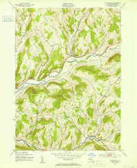
1943 Map of Bloomville
USGS Topo · Published 1971About this map
Bloomville and the West Branch Delaware River anchor this mid-century portrait of Delaware County's rural uplands. The landscape is defined by the valley of the New York Central Railroad, which follows the river's winding path toward the northeast. This 1940s survey reveals a dense network of one-room schoolhouses and family cemeteries that speak to the established dairy farming communities of the era. Significant landmarks include Federal Hill Sch, Pink St Sch, and Riverside Cem. Further south, the Little Delaware River flows through Bovina Center, a hub of local activity. The topography is dominated by prominent elevations such as Bramley Mtn and Bovina Mtn, which separate the various creek valleys. Researchers can trace the legacy of local families through features like Wetmore Cem and Sackrider Cem, positioned along the hillsides and tributary brooks.
Find a feature on this map
39 named features on this map. Tap any name to fly to it.
Don’t see what you’re looking for? This feature index may not catch every label — zoom into the map to look around manually.
Map Details
Editions of this 1943 Bloomville Map
Other maps of this area

1901 · Margaretville
USGS Topo · 1:62,500

1904 · Hobart
USGS Topo · 1:62,500

1904 · Margaretville
USGS Topo · 1:62,500

1909 · Delhi
USGS Topo · 1:62,500

1911 · Delhi
USGS Topo · 1:62,500

1922 · Andes
USGS Topo · 1:62,500

1924 · Andes
USGS Topo · 1:62,500

1943 · Delhi
USGS Topo · 1:24,000

1943 · Bloomville
USGS Topo · 1:24,000
1943 · West Davenport
USGS Topo · 1:24,000