1975 Map of Blountsville
USGS Topo · Published 1983About this map
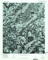
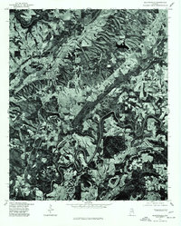
The Blountsville settlement serves as the central hub of this orthophotoquad, which captures the Alabama landscape as it appeared in late 1975. This specialized imagery, produced in cooperation with the Soil Conservation Service, emphasizes the texture of the terrain and land-use patterns rather than traditional topographic lines. The winding path of the Mulberry Fork cuts through the northwest corner and meanders across the southern reach of the map, illustrating the deep river bends that define the local geography. To the east, the smaller community of Royal sits amidst a patchwork of forested hills and cleared agricultural fields. The corridor of Route 231 provides a clear view of the primary transit artery connecting these rural communities, offering a detailed look at the physical structures and farm layouts of the mid-1970s.
Find a feature on this map
4 named features on this map. Tap any name to fly to it.
Don’t see what you’re looking for? This feature index may not catch every label — zoom into the map to look around manually.
Map Details
Editions of this 1975 Blountsville Map
2 editions found
Other maps of this area

1885 · Gadsden
USGS Topo · 1:125,000

1888 · Cullman
USGS Topo · 1:125,000

1888 · Gadsden
USGS Topo · 1:125,000

1889 · Springville
USGS Topo · 1:125,000

1889 · Birmingham
USGS Topo · 1:125,000

1892 · Cullman
USGS Topo · 1:125,000

1892 · Birmingham
USGS Topo · 1:125,000

1892 · Springville
USGS Topo · 1:125,000

1892 · Gadsden
USGS Topo · 1:125,000

1895 · Gadsden
USGS Topo · 1:125,000