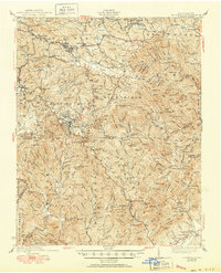
1942 Map of Blowing Rock
USGS Topo · Published 1950About this map
Blowing Rock sits along the crest of the Blue Ridge in this mid-century survey, a focal point where the Blue Ridge Parkway intersects with major routes like U.S. 221. The map reveals a landscape defined by sharp elevation changes and high summits, including Howard Knob and Rich Mtn. The settlement pattern follows the narrow valleys and creek beds, with small communities such as Shulls Mills and Perkinsville serving as local hubs.
Find a feature on this map
166 named features on this map. Tap any name to fly to it.
Don’t see what you’re looking for? This feature index may not catch every label — zoom into the map to look around manually.
Map Details
Editions of this 1942 Blowing Rock Map
4 editions found

Other maps of this area

1889 · Wilkesboro
USGS Topo · 1:125,000

1891 · Wilkesboro
USGS Topo · 1:125,000

1893 · Cranberry
USGS Topo · 1:125,000

1895 · Hickory
USGS Topo · 1:125,000

1895 · Cranberry
USGS Topo · 1:125,000

1899 · Cranberry
USGS Topo · 1:125,000

1902 · Cranberry
USGS Topo · 1:125,000

1905 · Morganton
USGS Topo · 1:125,000

1934 · Valle Crucis
USGS Topo · 1:24,000

1934 · Boone
USGS Topo · 1:24,000