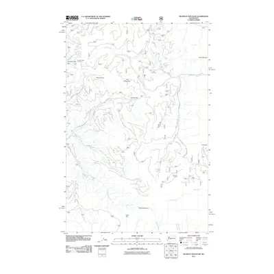
2011 Map of Blowout Mountain
USGS Topo · Published 2011About this map
Snowshoe Butte Lookout and Big Creek Lookout stand as prominent vantage points across this high-elevation terrain in King County. The landscape is defined by the headwaters of several major drainages, including the Green River, Cabin Creek, and Big Creek, which carve deep valleys between significant peaks like Blowout Mountain and Cabin Mountain. The map details an extensive network of National Forest roads, such as NFD 41 Rd and NFD 5220 Rd, which provide access to remote mountain passes including Sheets Pass, Tacoma Pass, and Green Pass. These routes reflect the mid-twentieth-century development of forest management and fire suppression infrastructure in the Cascades. For researchers and historians, the map's focus on peaks like Bearpaw Butte and Cole Butte offers a clear view of the geographic barriers and transit corridors that have shaped the region's resource-based economy.
Find a feature on this map
31 named features on this map. Tap any name to fly to it.
Don’t see what you’re looking for? This feature index may not catch every label — zoom into the map to look around manually.
Map Details
Editions of this 2011 Blowout Mountain Map
This is the sole edition of this map. No revisions or reprints were ever made.
Other maps of this area

1901 · Snoqualmie Pass
USGS Topo · 1:125,000

1903 · Snoqualmie
USGS Topo · 1:125,000

1957 · Wenatchee
USGS Topo · 1:250,000

1961 · Snoqualmie Pass
USGS Topo · 1:62,500

1961 · Easton
USGS Topo · 1:62,500

1961 · Kachess Lake
USGS Topo · 1:62,500

1962 · Lester
USGS Topo · 1:62,500

1975 · Snoqualmie Pass
USGS Topo · 1:100,000

1989 · Easton
USGS Topo · 1:24,000
1989 · Raven Roost
USGS Topo · 1:24,000