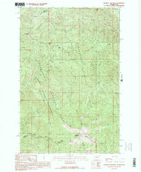
1989 Map of Blowout Mountain
USGS Topo · Published 1989About this map
The boundary between King and Kittitas counties bisects this high-elevation landscape, where the Snoqualmie National Forest meets the Wenatchee National Forest. The Pacific Crest National Scenic Trail winds through the center of the sheet, traversing key points like Sheets Pass and Tacoma Pass. This area is defined by its role as a critical water source, dominated by the Green River Watershed (City of Tacoma) which protects the headwaters of the Green River.
Find a feature on this map
19 named features on this map. Tap any name to fly to it.
Don’t see what you’re looking for? This feature index may not catch every label — zoom into the map to look around manually.
Map Details
Editions of this 1989 Blowout Mountain Map
This is the sole edition of this map. No revisions or reprints were ever made.
Other maps of this area

1901 · Snoqualmie Pass
USGS Topo · 1:125,000

1903 · Snoqualmie
USGS Topo · 1:125,000

1957 · Wenatchee
USGS Topo · 1:250,000

1961 · Snoqualmie Pass
USGS Topo · 1:62,500

1961 · Easton
USGS Topo · 1:62,500

1961 · Kachess Lake
USGS Topo · 1:62,500

1962 · Lester
USGS Topo · 1:62,500

1975 · Snoqualmie Pass
USGS Topo · 1:100,000

1989 · Easton
USGS Topo · 1:24,000
1989 · Raven Roost
USGS Topo · 1:24,000