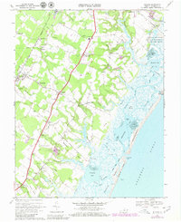
1968 Map of Bloxom
USGS Topo · Published 1980About this map
The Maryland and Virginia RR cuts a straight path through the heart of this coastal landscape, connecting agricultural and maritime settlements like Bloxom and Mappsville. This 1968 survey, updated with 1978 photogrammetric revisions, reveals a transition from traditional Eastern Shore life to modern aeronautics with the presence of the National Aeronautics and Space Administration (Wallops Flight Center) overlooking Oyster Bay.
Find a feature on this map
81 named features on this map. Tap any name to fly to it.
Don’t see what you’re looking for? This feature index may not catch every label — zoom into the map to look around manually.
Map Details
Editions of this 1968 Bloxom Map
4 editions found
Other maps of this area

1931 · Accomac
USGS Topo · 1:48,000

1935 · Accomac
USGS Topo · 1:62,500

1942 · Mappsville
USGS Topo · 1:24,000

1942 · Wallops Island
USGS Topo · 1:24,000

1942 · Saxis
USGS Topo · 1:24,000

1942 · Parksley
USGS Topo · 1:24,000

1943 · Parksley
USGS Topo · 1:31,680

1943 · Saxis
USGS Topo · 1:31,680

1943 · Mappsville
USGS Topo · 1:31,680

1943 · Chincoteague West
USGS Topo · 1:31,680