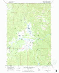
1972 Map of Blue Bunch Mtn
USGS Topo · Published 1977About this map
Bear Valley Meadows and the surrounding high country of the Boise National Forest dominate this early 1970s topographic study. The landscape is defined by the winding course of Bear Valley Creek, which gathers tributaries like Dagger Creek, Wyoming Creek, and Cold Creek as it moves through the valley floor. Evidence of backcountry recreation and light infrastructure is visible at the Bruce Meadows Landing Strip and several established sites including Bear Valley Campground and Fir Creek Campground.
Find a feature on this map
29 named features on this map. Tap any name to fly to it.
Don’t see what you’re looking for? This feature index may not catch every label — zoom into the map to look around manually.
Map Details
Editions of this 1972 Blue Bunch Mtn Map
2 editions found
Other maps of this area

1891 · Bear Valley
USGS Topo · 1:125,000

1893 · Bear Valley
USGS Topo · 1:125,000

1957 · Challis
USGS Topo · 1:250,000

1960 · Challis
USGS Topo · 1:250,000

1961 · Greyhound Ridge
USGS Topo · 1:62,500

1961 · Chinook Mtn
USGS Topo · 1:62,500

1963 · Challis
USGS Topo · 1:250,000

1972 · Bull Trout Point
USGS Topo · 1:24,000
1972 · Banner Summit
USGS Topo · 1:24,000

1972 · Cache Creek
USGS Topo · 1:24,000