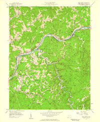
1957 Map of Blue Creek
USGS Topo · Published 1959About this map
The Elk River winds through this 1957 landscape, serving as a corridor for both the Baltimore and Ohio railroad and an intense network of energy extraction. This survey reveals a terrain saturated with thousands of oil and gas wells, particularly concentrated on the slopes above Blue Creek and Walgrove. Despite the heavy industrial footprint, the region maintains a dense fabric of small rural communities and family landmarks.
Find a feature on this map
72 named features on this map. Tap any name to fly to it.
Don’t see what you’re looking for? This feature index may not catch every label — zoom into the map to look around manually.
Map Details
Editions of this 1957 Blue Creek Map
4 editions found
Other maps of this area

1897 · Kanawha Falls
USGS Topo · 1:125,000

1899 · Charleston
USGS Topo · 1:125,000

1900 · Kanawha Falls
USGS Topo · 1:125,000

1901 · Kanawha Falls
USGS Topo · 1:125,000

1906 · Kenna
USGS Topo · 1:62,500

1906 · Walton
USGS Topo · 1:62,500

1907 · Kenna
USGS Topo · 1:62,500

1907 · Walton
USGS Topo · 1:62,500

1907 · Clendenin
USGS Topo · 1:62,500

1909 · Charleston
USGS Topo · 1:62,500