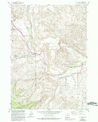
1952 Map of Blue Holes
USGS Topo · Published 1993About this map
The Wind River carves a deep valley through this portion of Fremont County, serving as the primary geographical divider between the Wind River Indian Reservation and the Shoshone National Forest. This mid-century survey reveals a landscape shaped by both natural waterways and early 20th-century resource management. Evidence of the area's industrial past is seen in the Coal Mine (Aband) near Coal Draw, while state-managed conservation efforts are anchored by the State Game and Fish Checking Station at the confluence of the river and Wiggins Fork. To the south, high-altitude terrain is dominated by Table Mountain and the Fitzpatrick Wilderness, where the Miller Red Creek Ditch indicates an organized effort to divert water from Red Creek for local use. A remote Landing Strip further emphasizes the isolation of this western terrain during the 1950s.
Find a feature on this map
17 named features on this map. Tap any name to fly to it.
Don’t see what you’re looking for? This feature index may not catch every label — zoom into the map to look around manually.
Map Details
Editions of this 1952 Blue Holes Map
4 editions found
Other maps of this area

1904 · Kirwin
USGS Topo · 1:125,000

1905 · Younts Peak
USGS Topo · 1:125,000

1906 · Kirwin
USGS Topo · 1:125,000

1907 · Younts Peak
USGS Topo · 1:125,000

1909 · Fremont Peak
USGS Topo · 1:125,000

1952 · Wilderness
USGS Topo · 1:24,000

1952 · Hays Park
USGS Topo · 1:24,000

1952 · Blue Holes
USGS Topo · 1:24,000

1952 · Burris
USGS Topo · 1:24,000

1955 · Thermopolis
USGS Topo · 1:250,000