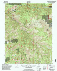
1994 Map of Blue Nose Mountain
USGS Topo · Published 1998About this map
The Middle Fork Feather River carves a deep path through the northern reach of this quadrangle, defining the steep elevation changes that once drove the region's mining and hydraulic operations. By the mid-1990s, the landscape within the Plumas National Forest shows a transition from active extraction to recreation and preservation, with the Pacific Crest Nat Scenic Trail traversing the high ridges. Remnants of the Gold Rush era are preserved in the locations of the Nelson Point (Site) and several scattered operations such as the Buckhorn Mine and Bunker Hill Mine.
Find a feature on this map
49 named features on this map. Tap any name to fly to it.
Don’t see what you’re looking for? This feature index may not catch every label — zoom into the map to look around manually.
Map Details
Editions of this 1994 Blue Nose Mountain Map
This is the sole edition of this map. No revisions or reprints were ever made.
Other maps of this area

1891 · Downieville
USGS Topo · 1:125,000

1893 · Downieville
USGS Topo · 1:125,000

1895 · Downieville
USGS Topo · 1:125,000

1896 · Downieville
USGS Topo · 1:125,000

1897 · Downieville
USGS Topo · 1:125,000

1937 · Blairsden
USGS Topo · 1:48,000

1943 · Blairsden
USGS Topo · 1:62,500
1950 · Spring Garden
USGS Topo · 1:24,000
1950 · Quincy
USGS Topo · 1:24,000
1950 · Onion Valley
USGS Topo · 1:24,000