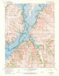
1968 Map of Blue Rapids SE
USGS Topo · Published 1969About this map
Tuttle Creek Reservoir dominates the landscape where the Big Blue River and Black Vermillion River converge in Marshall and Pottawatomie counties. This late 1960s survey captures the transformation of the river valleys into a managed aquatic environment, with large areas designated as the Tuttle Creek State Wildlife Management Area. Cultural landmarks such as the Proctor Cem and topographic features like Indian Mound and Twin Mounds remain as markers of the previous terrain.
Find a feature on this map
25 named features on this map. Tap any name to fly to it.
Don’t see what you’re looking for? This feature index may not catch every label — zoom into the map to look around manually.
Map Details
Editions of this 1968 Blue Rapids SE Map
2 editions found

Other maps of this area

1886 · Junction City
USGS Topo · 1:125,000

1889 · Seneca
USGS Topo · 1:125,000

1889 · Wamego
USGS Topo · 1:125,000

1889 · Marysville
USGS Topo · 1:125,000

1889 · Junction City
USGS Topo · 1:125,000

1894 · Junction City
USGS Topo · 1:125,000

1894 · Seneca
USGS Topo · 1:125,000

1894 · Marysville
USGS Topo · 1:125,000

1894 · Wamego
USGS Topo · 1:125,000

1955 · Manhattan
USGS Topo · 1:250,000