
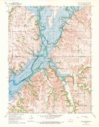
1968 Map of Blue Rapids SE
USGS Topo · Published 1983About this map
Tuttle Creek Lake dominates the central landscape of this 1960s survey, representing the massive hydrological changes that redefined the Big Blue River valley. The presence of an Old Railroad Grade and the Proctor Cem offer clues to the pre-inundation settlement patterns of Marshall and Pottawatomie counties. Much of the riparian zone is dedicated to the Tuttle Creek Lake State Wildlife Management Area, preserving the confluence where the Vermillion River meets the main channel. Distinctive topographic features like Indian Mound and Twin Mounds rise above the surrounding drainages of Game Fork and Spring Creek, while scattered industrial activity is marked by a Quarry and Sandpit. The map captures a moment when the regional focus shifted from the old rail-and-river economy toward large-scale conservation and water management.
Find a feature on this map
22 named features on this map. Tap any name to fly to it.
Don’t see what you’re looking for? This feature index may not catch every label — zoom into the map to look around manually.
Map Details
Editions of this 1968 Blue Rapids SE Map
2 editions found
Other maps of this area

1886 · Junction City
USGS Topo · 1:125,000

1889 · Seneca
USGS Topo · 1:125,000

1889 · Wamego
USGS Topo · 1:125,000

1889 · Marysville
USGS Topo · 1:125,000

1889 · Junction City
USGS Topo · 1:125,000

1894 · Junction City
USGS Topo · 1:125,000

1894 · Seneca
USGS Topo · 1:125,000

1894 · Marysville
USGS Topo · 1:125,000

1894 · Wamego
USGS Topo · 1:125,000

1955 · Manhattan
USGS Topo · 1:250,000