
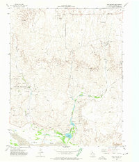
1967 Map of Blue Ridge School
USGS Topo · Published 1969About this map
The Canadian River dominates the northern landscape of Hemphill County, where the Texas Water Development Board documented a complex system of drainage and terrain in the late 1960s. This survey captures a rural landscape defined by the divide between the Canadian watershed and the headwaters of the Dry Fork Washita River to the south. Central to this community is the Blue Ridge Sch, a focal point for local families in an area otherwise marked by ranching features like fine red dashed fence lines. The topography reveals significant local landmarks such as Jo Spring and a series of north-flowing tributaries including Big Timber Creek, Needmore Creek, and Turkey Creek. Large fields of Sand Dunes near the riverbanks and a prominent Pipeline crossing the panhandle plains illustrate the intersection of natural geography and mid-century utility infrastructure.
Find a feature on this map
13 named features on this map. Tap any name to fly to it.
Don’t see what you’re looking for? This feature index may not catch every label — zoom into the map to look around manually.
Map Details
Editions of this 1967 Blue Ridge School Map
This is the sole edition of this map. No revisions or reprints were ever made.
Other maps of this area

1954 · Amarillo
USGS Topo · 1:250,000

1958 · Amarillo
USGS Topo · 1:250,000

1967 · Dads Creek
USGS Topo · 1:24,000

1967 · Gem
USGS Topo · 1:24,000

1967 · Hackberry Creek
USGS Topo · 1:24,000

1967 · Lake June
USGS Topo · 1:24,000

1967 · Canadian SE
USGS Topo · 1:24,000

1972 · Canadian East
USGS Topo · 1:24,000
1972 · Lake Marvin
USGS Topo · 1:24,000
1972 · Dreyfoos
USGS Topo · 1:24,000