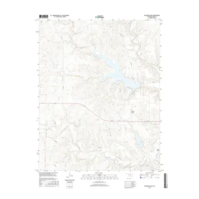
2016 Map of Bluestem Lake
USGS Topo · Published 2016About this map
Bluestem Lake and the surrounding drainage of Bird Creek dominate this 2016 Osage County survey, illustrating the hydrologic character of the Oklahoma prairie. The landscape is defined by the sinuous forms of these reservoirs and the deep cuts of Cedar Canyon, showing how modern water management and aviation have shaped the region west of the county seat. The Pawhuska Municipal Airport occupies a central plateau, situated between the north-flowing waters of Middle Bird Cr and the larger catchment of Pawhuska Lake.
Find a feature on this map
25 named features on this map. Tap any name to fly to it.
Don’t see what you’re looking for? This feature index may not catch every label — zoom into the map to look around manually.
Map Details
Editions of this 2016 Bluestem Lake Map
This is the sole edition of this map. No revisions or reprints were ever made.
Other maps of this area

1909 · Pawhuska
USGS Topo · 1:125,000

1910 · Pawhuska
USGS Topo · 1:125,000

1916 · Foraker
USGS Topo · 1:62,500

1932 · Fairfax
USGS Topo · 1:62,500

1955 · Enid
USGS Topo · 1:250,000

1958 · Enid
USGS Topo · 1:250,000

1960 · Nanos
USGS Topo · 1:24,000

1960 · Pawhuska
USGS Topo · 1:24,000
1964 · Wynona
USGS Topo · 1:24,000
1973 · Happy Hollow
USGS Topo · 1:24,000