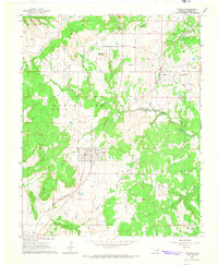
1964 Map of Wynona
USGS Topo · Published 1965About this map
The Wynona Oil Field and surrounding petroleum districts dominate this Osage County landscape, revealing an intensive pattern of energy extraction during the mid-1960s. The town of Wynona serves as the central hub, situated along the Missouri - Kansas - Texas railroad line. To the north, the smaller settlement of Pershing is nearly encircled by the Pershing Oil Field, illustrating how closely residential life and industry were integrated in this region.
Find a feature on this map
19 named features on this map. Tap any name to fly to it.
Don’t see what you’re looking for? This feature index may not catch every label — zoom into the map to look around manually.
Map Details
Editions of this 1964 Wynona Map
2 editions found
Other maps of this area

1906 · Nelagoney
USGS Topo · 1:24,000

1909 · Pawhuska
USGS Topo · 1:125,000

1910 · Pawhuska
USGS Topo · 1:125,000

1912 · Hominy
USGS Topo · 1:125,000

1915 · Hominy
USGS Topo · 1:125,000

1915 · Hominy
USGS Topo · 1:62,500

1955 · Enid
USGS Topo · 1:250,000

1958 · Enid
USGS Topo · 1:250,000

1960 · Nelagoney
USGS Topo · 1:24,000

1960 · Pawhuska
USGS Topo · 1:24,000