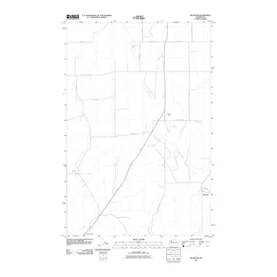
2011 Map of Bluestem
USGS Topo · Published 2011About this map
Bluestem sits at the heart of this agricultural landscape in Lincoln County, where the intersection of rural road networks and natural watercourses defines the local geography. The area is marked by the winding paths of Bluestem Creek and Lords Creek, which cut through the terrain alongside distinctive features like Bruns Flat and Tanner Lake. Transportation and land use are central to the map's character, evidenced by the presence of Hanes Airport and a grid of family-named roads such as Mayberry Rd E, Scharff Rd N, and Deking Rd E. A notable piece of Cold War-era legacy is preserved in the naming of Old Missile Site Rd N, hinting at the region's strategic importance in the mid-20th century. The drainage patterns of Coal Creek further illustrate the watershed's role in shaping the high-plateau environment of eastern Washington.
Find a feature on this map
27 named features on this map. Tap any name to fly to it.
Don’t see what you’re looking for? This feature index may not catch every label — zoom into the map to look around manually.
Map Details
Editions of this 2011 Bluestem Map
This is the sole edition of this map. No revisions or reprints were ever made.
Other maps of this area

1953 · Ritzville
USGS Topo · 1:250,000

1959 · Ritzville
USGS Topo · 1:250,000

1965 · Ritzville
USGS Topo · 1:250,000

1969 · Bluestem
USGS Topo · 1:24,000

1969 · Harrington
USGS Topo · 1:24,000

1969 · Lords Valley
USGS Topo · 1:24,000
1969 · Mondovi
USGS Topo · 1:24,000

1969 · Rocklyn
USGS Topo · 1:24,000

1969 · Omans
USGS Topo · 1:24,000
1969 · Rocklyn SE
USGS Topo · 1:24,000