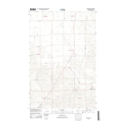
2013 Map of Bluestem
USGS Topo · Published 2013About this map
Bluestem sits at the heart of this agricultural landscape in Lincoln County, where the topography is defined by the winding course of Bluestem Cr and the broad expanse of Bruns Flat. The area is a network of rural routes named for early settling families, including Buck Flats Rd N and Scharff Rd N, reflecting the deep-rooted ranching and farming history of the region. To the south, Lords Valley provides a natural corridor for Lords Cr, while the small Tanner Lake and Coal Cr punctuate the northern and central sections of the terrain. Aviation history is noted by the presence of Hanes Airport near the southern boundary. This survey documents the persistent rural character of the Big Bend Country, where infrastructure like Wa-28 facilitates movement through a landscape still partitioned by historic township and range lines.
Find a feature on this map
37 named features on this map. Tap any name to fly to it.
Don’t see what you’re looking for? This feature index may not catch every label — zoom into the map to look around manually.
Map Details
Editions of this 2013 Bluestem Map
This is the sole edition of this map. No revisions or reprints were ever made.
Other maps of this area

1953 · Ritzville
USGS Topo · 1:250,000

1959 · Ritzville
USGS Topo · 1:250,000

1965 · Ritzville
USGS Topo · 1:250,000

1969 · Bluestem
USGS Topo · 1:24,000

1969 · Harrington
USGS Topo · 1:24,000

1969 · Lords Valley
USGS Topo · 1:24,000
1969 · Mondovi
USGS Topo · 1:24,000

1969 · Rocklyn
USGS Topo · 1:24,000

1969 · Omans
USGS Topo · 1:24,000
1969 · Rocklyn SE
USGS Topo · 1:24,000