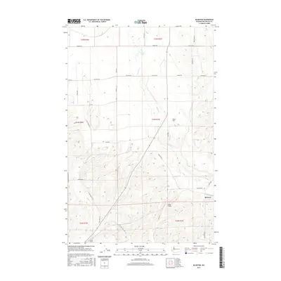
2017 Map of Bluestem
USGS Topo · Published 2017About this map
The small community of Bluestem sits at the junction of several rural routes in this section of Lincoln County, defined by a landscape of coulees and seasonal drainages. The area is dominated by the winding course of Bluestem Cr, which flows through the center of the map toward Bruns Flat and Lords Valley. These low-lying terrain features reflect the unique geology of the region, where water has carved distinct paths through the basalt-rich plateau. In the southern portion of the quadrangle, Lords Cr and Coal Cr converge, while the northern reaches include the isolated Tanner Lake. The map reveals a high density of named country roads, such as Mayberry Rd and Zellmer Rd E, which trace the section lines of the Public Land Survey System. For aviation history, the presence of Hanes Airport in the southwest corner marks a notable local landmark within this agricultural and ranching landscape.
Find a feature on this map
40 named features on this map. Tap any name to fly to it.
Don’t see what you’re looking for? This feature index may not catch every label — zoom into the map to look around manually.
Map Details
Editions of this 2017 Bluestem Map
This is the sole edition of this map. No revisions or reprints were ever made.
Other maps of this area

1953 · Ritzville
USGS Topo · 1:250,000

1959 · Ritzville
USGS Topo · 1:250,000

1965 · Ritzville
USGS Topo · 1:250,000

1969 · Bluestem
USGS Topo · 1:24,000

1969 · Harrington
USGS Topo · 1:24,000

1969 · Lords Valley
USGS Topo · 1:24,000
1969 · Mondovi
USGS Topo · 1:24,000

1969 · Rocklyn
USGS Topo · 1:24,000

1969 · Omans
USGS Topo · 1:24,000
1969 · Rocklyn SE
USGS Topo · 1:24,000