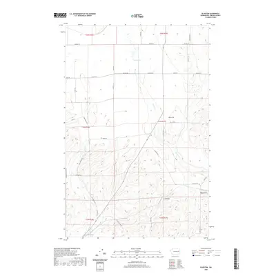
2020 Map of Bluestem
USGS Topo · Published 2020About this map
The small settlement of Bluestem serves as the focal point for this section of Lincoln County, situated near the headwaters of Lords Cr and Bluestem Cr. The landscape is defined by the gradual descent into Bruns Flat and Lords Valley, where the drainage patterns of Coal Cr carve through the terrain. In the northern reaches, Tanner Lake provides a localized water source amidst a grid of rural roads named for early area families, including Scharff Rd, Jahn Rd, and Lindstrom Rd. Transport and accessibility are highlighted by the presence of Hanes Airport in the southwest corner and the historic path of Old White Stone Rd, reflecting the region's long-standing agricultural and aviation character.
Find a feature on this map
38 named features on this map. Tap any name to fly to it.
Don’t see what you’re looking for? This feature index may not catch every label — zoom into the map to look around manually.
Map Details
Editions of this 2020 Bluestem Map
This is the sole edition of this map. No revisions or reprints were ever made.
Other maps of this area

1953 · Ritzville
USGS Topo · 1:250,000

1959 · Ritzville
USGS Topo · 1:250,000

1965 · Ritzville
USGS Topo · 1:250,000

1969 · Bluestem
USGS Topo · 1:24,000

1969 · Harrington
USGS Topo · 1:24,000

1969 · Lords Valley
USGS Topo · 1:24,000
1969 · Mondovi
USGS Topo · 1:24,000

1969 · Rocklyn
USGS Topo · 1:24,000

1969 · Omans
USGS Topo · 1:24,000
1969 · Rocklyn SE
USGS Topo · 1:24,000