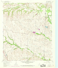
1960 Map of Bluett
USGS Topo · Published 1969About this map
Bluett stands as the central point of reference in this rural landscape along the boundary shared by Wise Co and Denton Co. The settlement pattern is defined by upland ridges and a dense network of drainages, including the winding course of Denton Creek and Oliver Creek. In the late 1950s and early 1960s, these lands remained primarily agricultural, marked by numerous fence and field lines recorded from aerial photography. Local social and spiritual life is anchored by community landmarks such as Corinth Ch and Sweetwater Ch. To the southwest, the Fort Worth and Denver (Burlington) railroad cuts across the terrain, reflecting the vital transport corridor connecting this region to the larger Texas rail network. Pockets of resource extraction are visible through several Gravel Pits and a Gas Well, indicating the area's early industrial diversification alongside traditional ranching.
Find a feature on this map
18 named features on this map. Tap any name to fly to it.
Don’t see what you’re looking for? This feature index may not catch every label — zoom into the map to look around manually.
Map Details
Editions of this 1960 Bluett Map
3 editions found
Other maps of this area

1924 · Sunset 4-d
USGS Topo · 1:48,000

1930 · Boyd
USGS Topo · 1:62,500

1954 · Sherman
USGS Topo · 1:250,000

1958 · Sherman
USGS Topo · 1:250,000

1959 · Ponder
USGS Topo · 1:24,000

1960 · Decatur
USGS Topo · 1:24,000

1960 · Boyd
USGS Topo · 1:24,000
1960 · Justin
USGS Topo · 1:24,000

1960 · Bluett
USGS Topo · 1:24,000

1960 · Rhome
USGS Topo · 1:24,000