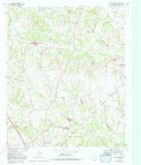
1961 Map of Pecan Creek
USGS Topo · Published 1992About this map
Decatur and its immediate rural surroundings are captured here at a moment of transition during the early 1960s, with land-use revisions reflecting changes through the mid-1970s. The landscape is defined by the drainage systems of Black Creek, Pecan Creek, and Catlett Creek, which carve through the terrain and dictate the placement of early road networks like Decatur Road. The southern edge of the quadrangle shows the expansion of the town near Oaklawn Cem, while the outlying areas remain anchored by community landmarks such as Flat Rock Ch and its adjacent Flat Rock Cem. The map reveals a diversified local economy, where traditional agriculture intersects with extractive industries like the Gravel Pit and the development of the North Southeast Bryson Oil Field. Aviation and scientific infrastructure are also evident in the presence of the Decatur Airfield and the Decatur Magnetic station, marking the town's regional importance.
Find a feature on this map
22 named features on this map. Tap any name to fly to it.
Don’t see what you’re looking for? This feature index may not catch every label — zoom into the map to look around manually.
Map Details
Editions of this 1961 Pecan Creek Map
4 editions found
Other maps of this area

1930 · Boyd
USGS Topo · 1:62,500

1954 · Sherman
USGS Topo · 1:250,000

1958 · Sherman
USGS Topo · 1:250,000

1960 · Bridgeport East
USGS Topo · 1:24,000

1960 · Decatur
USGS Topo · 1:24,000

1960 · Bluett
USGS Topo · 1:24,000

1961 · Pecan Creek
USGS Topo · 1:24,000

1961 · Alvord
USGS Topo · 1:24,000

1961 · New Harp
USGS Topo · 1:24,000

1961 · Slidell
USGS Topo · 1:24,000