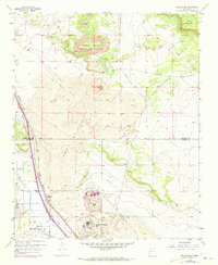
1957 Map of Bluewater
USGS Topo · Published 1973About this map
Haystack Mountain and the jagged volcanic expanse of The Malpais dominate this high-desert landscape northwest of Grants. The 1950s era of industrial growth is clearly visible here, marked by the prominent Anaconda Bluewater Mill and its associated Tailings Pond, signifying the region's mid-century uranium processing activity. The San Jose River provides a lifeline through the valley, supporting agricultural infrastructure like the Middle Ditch and Main Ditch near the village of Bluewater.
Find a feature on this map
22 named features on this map. Tap any name to fly to it.
Don’t see what you’re looking for? This feature index may not catch every label — zoom into the map to look around manually.
Map Details
Editions of this 1957 Bluewater Map
3 editions found

Other maps of this area

1883 · Mt. Taylor
USGS Topo · 1:250,000

1886 · Wingate
USGS Topo · 1:250,000

1886 · Mt. Taylor
USGS Topo · 1:250,000

1892 · Wingate
USGS Topo · 1:250,000

1892 · Mt. Taylor
USGS Topo · 1:250,000

1899 · Mt. Taylor
USGS Topo · 1:250,000

1951 · Mt Sedgwick
USGS Topo · 1:24,000

1954 · Gallup
USGS Topo · 1:250,000

1957 · Ambrosia Lake
USGS Topo · 1:24,000

1957 · Dos Lomas
USGS Topo · 1:24,000