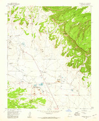
1957 Map of Bluewater
USGS Topo · Published 1981About this map
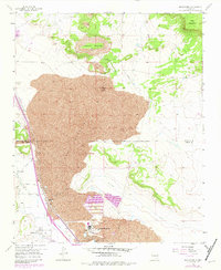
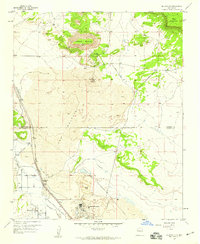
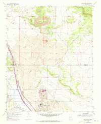
Haystack Mountain and Mesa Montañosa dominate the northern skyline of this high-desert landscape, where volcanic history is written across the earth. A massive expanse of Lava known as The Malpais flows through the center of the quadrangle, punctuated by the cinder cone of El Tintero. This geological terrain dictates the human geography, forcing settlement and industry to the southwest along the corridor of the San Jose Rio.
Find a feature on this map
22 named features on this map. Tap any name to fly to it.
Don’t see what you’re looking for? This feature index may not catch every label — zoom into the map to look around manually.
Map Details
Editions of this 1957 Bluewater Map
3 editions found
Other maps of this area

1883 · Mt. Taylor
USGS Topo · 1:250,000

1886 · Wingate
USGS Topo · 1:250,000

1886 · Mt. Taylor
USGS Topo · 1:250,000

1892 · Wingate
USGS Topo · 1:250,000

1892 · Mt. Taylor
USGS Topo · 1:250,000

1899 · Mt. Taylor
USGS Topo · 1:250,000
1951 · Mt Sedgwick
USGS Topo · 1:24,000

1954 · Gallup
USGS Topo · 1:250,000
1957 · Ambrosia Lake
USGS Topo · 1:24,000
1957 · Dos Lomas
USGS Topo · 1:24,000