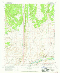
1962 Map of Bluff
USGS Topo · Published 1969About this map
Bluff sits at the southern edge of this San Juan County landscape, positioned where the high desert plateaus drop toward the San Juan River. The 1960s geography is defined by immense geological formations like the striking Comb Ridge and the broad expanses of White Mesa and Black Mesa. Cultural history is deeply layered here, featuring the Mormon Road tracing a path through the sandstone and the St Christophers Mission established near the riverbanks. Numerous archaeological sites are documented throughout the canyons, specifically numerous cliff dwellings found within the alcoves of Butler Wash and Cottonwood Canyon. To the south, the boundary of the Navajo Indian Reservation begins across the river, near landmarks such as the Navajo Twins and the Navajo Spring. The map also captures local ranching life at the Decker Ranch and the isolated settlement at Stevens.
Find a feature on this map
43 named features on this map. Tap any name to fly to it.
Don’t see what you’re looking for? This feature index may not catch every label — zoom into the map to look around manually.
Map Details
Editions of this 1962 Bluff Map
3 editions found

Other maps of this area

1886 · Abajo
USGS Topo · 1:250,000

1892 · Abajo
USGS Topo · 1:250,000

1893 · Abajo
USGS Topo · 1:250,000

1935 · Elk Ridge
USGS Topo · 1:96,000

1940 · Elk Ridge
USGS Topo · 1:125,000

1954 · Elk Ridge 3 SE
USGS Topo · 1:24,000

1954 · Bears Ears
USGS Topo · 1:62,500

1956 · Cortez
USGS Topo · 1:250,000

1957 · Elk Ridge 4 SE
USGS Topo · 1:24,000

1957 · Brushy Basin Wash
USGS Topo · 1:62,500