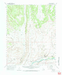
1962 Map of Bluff
USGS Topo · Published 1984About this map
The San Juan River defines the southern reach of this landscape, where the settlement of Bluff sits at the foot of towering sandstone formations. This 1962 survey records the town and its surroundings during a period of relative isolation, connected by the Mormon Road and the Bluff Road. Cultural landmarks such as the St Christophers Mission and ancient Cliff Dwellings underscore a long history of human habitation in the river valley.
Find a feature on this map
45 named features on this map. Tap any name to fly to it.
Don’t see what you’re looking for? This feature index may not catch every label — zoom into the map to look around manually.
Map Details
Editions of this 1962 Bluff Map
3 editions found

Other maps of this area

1886 · Abajo
USGS Topo · 1:250,000

1892 · Abajo
USGS Topo · 1:250,000

1893 · Abajo
USGS Topo · 1:250,000

1935 · Elk Ridge
USGS Topo · 1:96,000

1940 · Elk Ridge
USGS Topo · 1:125,000

1954 · Elk Ridge 3 SE
USGS Topo · 1:24,000

1954 · Bears Ears
USGS Topo · 1:62,500

1956 · Cortez
USGS Topo · 1:250,000

1957 · Elk Ridge 4 SE
USGS Topo · 1:24,000

1957 · Brushy Basin Wash
USGS Topo · 1:62,500