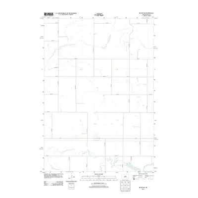
2012 Map of Blunt SE
USGS Topo · Published 2012About this map
Medicine Knoll Cr meanders across this rural landscape in central South Dakota, defining the drainage patterns of Hughes County. The terrain is structured by a rigorous sectional grid of gravel roads and section lines, including 315th Ave and 191st St. In the southern portion of the quadrangle, the S Fork Medicine Knoll Cr flows past Swanson Lake and Woodruff Lake, where the land becomes more varied near the Co Hwy-202 corridor. The presence of Pearson Pl and several isolated farmsteads indicates a persistent agricultural footprint typical of the High Plains. This 2012 survey documents the region's late 20th-century transportation infrastructure, anchored by the primary east-west route of Highway 14.
Find a feature on this map
21 named features on this map. Tap any name to fly to it.
Don’t see what you’re looking for? This feature index may not catch every label — zoom into the map to look around manually.
Map Details
Editions of this 2012 Blunt SE Map
This is the sole edition of this map. No revisions or reprints were ever made.
Other maps of this area

1953 · Huron
USGS Topo · 1:250,000

1954 · Huron
USGS Topo · 1:250,000

1967 · Blunt
USGS Topo · 1:24,000

1967 · Blunt SE
USGS Topo · 1:24,000

1967 · De Grey NE
USGS Topo · 1:24,000
1967 · Blunt NW
USGS Topo · 1:24,000

1967 · Blunt NE
USGS Topo · 1:24,000
1967 · De Grey NW
USGS Topo · 1:24,000

1968 · Harrold NW
USGS Topo · 1:24,000

1968 · Harrold
USGS Topo · 1:24,000