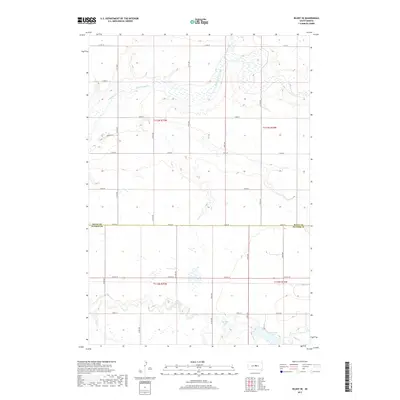
2017 Map of Blunt SE
USGS Topo · Published 2017About this map
Medicine Knoll Creek meanders across this rural landscape at the border of Sully and Hughes Counties, defining the local drainage patterns of the Great Plains. The terrain is marked by a network of sectional roads and localized depressions, including small water bodies such as Swanson Lake and Woodruff Lake. These features, along with names like Pearson Pl, suggest a history of family-held land and agricultural development typical of South Dakota's interior. The map illustrates a strictly organized township and range grid, where long straight stretches like 197th St and Co Rd 202 facilitate travel between scattered farmsteads and rural properties.
Find a feature on this map
19 named features on this map. Tap any name to fly to it.
Don’t see what you’re looking for? This feature index may not catch every label — zoom into the map to look around manually.
Map Details
Editions of this 2017 Blunt SE Map
This is the sole edition of this map. No revisions or reprints were ever made.
Other maps of this area

1953 · Huron
USGS Topo · 1:250,000

1954 · Huron
USGS Topo · 1:250,000

1967 · Blunt
USGS Topo · 1:24,000

1967 · Blunt SE
USGS Topo · 1:24,000

1967 · De Grey NE
USGS Topo · 1:24,000
1967 · Blunt NW
USGS Topo · 1:24,000

1967 · Blunt NE
USGS Topo · 1:24,000
1967 · De Grey NW
USGS Topo · 1:24,000

1968 · Harrold NW
USGS Topo · 1:24,000

1968 · Harrold
USGS Topo · 1:24,000