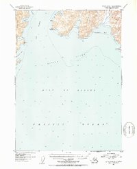
1953 Map of Blying Sound D-6
USGS Topo · Published 1954About this map
Resurrection Peninsula defines the western edge of this coastal survey, where the deep waters of Day Harbor meet the open Gulf of Alaska. Mapped shortly after mid-century using aerial photography from 1950, the topography captures the maritime character of the Kenai Peninsula coastline before modern development. Notable coastal landmarks such as Cape Fairfield and Cape Mansfield frame the expansive Whidbey Bay, while several smaller inlets like Safety Cove and Driftwood Bay provide natural anchorage along the jagged shore. The interior terrain is marked by steep ridges and specific survey points like VABM 118 Chimney and VABM 62 Gos. This map serves as a primary record of the shoreline and bathymetry in Blying Sound during the early 1950s, detailing depths and coastal features vital for maritime history and navigation.
Find a feature on this map
21 named features on this map. Tap any name to fly to it.
Don’t see what you’re looking for? This feature index may not catch every label — zoom into the map to look around manually.
Map Details
Editions of this 1953 Blying Sound D-6 Map
2 editions found
Other maps of this area

1946 · Blying Sound
USGS Topo · 1:250,000

1950 · Seward A-6
USGS Topo · 1:63,360

1950 · Blying Sound D-7
USGS Topo · 1:63,360

1950 · Blying Sound D-6
USGS Topo · 1:63,360

1950 · Seward A-7
USGS Topo · 1:63,360

1950 · Blying Sound D-5
USGS Topo · 1:63,360

1951 · Blying Sound
USGS Topo · 1:250,000

1951 · Seward
USGS Topo · 1:250,000

1951 · Seward A-6
USGS Topo · 1:63,360

1951 · Seward A-7
USGS Topo · 1:63,360