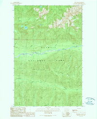
1990 Map of Bob Creek
USGS Topo · Published 1990About this map
Olympic National Park defines this 1990 survey of the Olympic Peninsula, centered on the winding corridor of the Queets River. This wilderness landscape is characterized by a dense network of watercourses, including Tshletshy Creek and Pelton Creek, which drain the prominent Tshletshy Ridge. The map captures a moment in the late twentieth century when human infrastructure was minimal, consisting largely of trails and remote outposts. A single structure, the Pelton Creek Shelter, is noted near the confluence of several streams, providing a rare point of reference for hikers and researchers tracking historical backcountry routes. The topography is defined by significant elevation changes, with peaks and ridges overlooking narrow valleys carved by Bob Creek and its tributaries.
Find a feature on this map
12 named features on this map. Tap any name to fly to it.
Don’t see what you’re looking for? This feature index may not catch every label — zoom into the map to look around manually.
Map Details
Editions of this 1990 Bob Creek Map
This is the sole edition of this map. No revisions or reprints were ever made.
Other maps of this area

1935 · Mount Olympus
USGS Topo · 1:62,500

1939 · Mount Tom
USGS Topo · 1:62,500

1942 · Mount Olympus
USGS Topo · 1:62,500

1947 · Mt Christie
USGS Topo · 1:62,500

1950 · Mt Christie
USGS Topo · 1:62,500

1956 · Mount Olympus
USGS Topo · 1:62,500

1956 · Kloochman Rock
USGS Topo · 1:62,500

1956 · Mount Tom
USGS Topo · 1:62,500
1957 · Mount Tom
USGS Topo · 1:62,500

1958 · Seattle
USGS Topo · 1:250,000