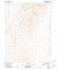
1981 Map of Bob Spring
USGS Topo · Published 1982About this map
Sahwave Mountains define the central topography of this Pershing County landscape, where the high ridges transition into the wide expanse of the Granite Springs Valley to the east. This 1981 survey, based on aerial data from the mid-1970s, reveals a terrain defined by sparse water sources and early mining interest. Vital water points such as Bob Spring and South Juniper Spring are identified near the slopes of Juniper Mtn, marking the rare locations where moisture reaches the surface in an otherwise arid environment. Evidence of mineral exploration is found near the southern end of the range, noted simply as Prospects. The map traces a network of unimproved roads and four-wheel-drive tracks that navigate the western foothills of Granite Springs Ridge, providing a clear view of the remote transportation corridors used by ranchers and prospectors during this era.
Find a feature on this map
8 named features on this map. Tap any name to fly to it.
Don’t see what you’re looking for? This feature index may not catch every label — zoom into the map to look around manually.
Map Details
Editions of this 1981 Bob Spring Map
This is the sole edition of this map. No revisions or reprints were ever made.
Other maps of this area

1886 · Granite Range
USGS Topo · 1:250,000

1894 · Granite Range
USGS Topo · 1:250,000

1931 · Lovelock
USGS Topo · 1:250,000

1935 · Lovelock
USGS Topo · 1:250,000

1955 · Lovelock
USGS Topo · 1:250,000

1959 · Lovelock
USGS Topo · 1:250,000
1981 · Bluewing Flat South
USGS Topo · 1:24,000
1981 · Tunnel Spring
USGS Topo · 1:24,000

1981 · Bluewing Flat North
USGS Topo · 1:24,000
1981 · Sage Hen Spring
USGS Topo · 1:24,000