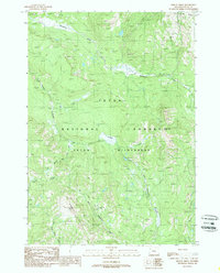
1989 Map of Bobcat Ridge
USGS Topo · Published 1989About this map
Teton Wilderness and the Teton National Forest dominate this landscape, defined by high-elevation ridges and an intricate drainage network. The topography is anchored by the prominent Bobcat Ridge and Big Game Ridge, which serve as significant water divides for the surrounding creek systems. High points such as Pinyon Peak provide strategic vantage points over a terrain largely untouched by modern development, preserved through its wilderness designation.
Find a feature on this map
16 named features on this map. Tap any name to fly to it.
Don’t see what you’re looking for? This feature index may not catch every label — zoom into the map to look around manually.
Map Details
Editions of this 1989 Bobcat Ridge Map
This is the sole edition of this map. No revisions or reprints were ever made.
Other maps of this area

1885 · Lake
USGS Topo · 1:125,000

1886 · Shoshone
USGS Topo · 1:125,000

1888 · Shoshone
USGS Topo · 1:125,000

1895 · Shoshone
USGS Topo · 1:125,000

1895 · Lake
USGS Topo · 1:125,000

1896 · Lake
USGS Topo · 1:125,000

1899 · Grand Teton
USGS Topo · 1:125,000

1901 · Shoshone
USGS Topo · 1:125,000

1901 · Lake
USGS Topo · 1:125,000

1901 · Grand Teton
USGS Topo · 1:125,000