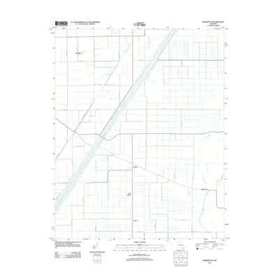
2012 Map of Boekerton
USGS Topo · Published 2012About this map
Boekerton and the surrounding agricultural lowlands of the Missouri Bootheel are defined by an intricate network of engineered drainage canals. This landscape, meticulously partitioned by a grid of county roads and highways, reflects the region's total transformation for large-scale farming. Central to this system is the massive Ditch Number 1, which runs diagonally alongside several other channels like Ditch Number 9 and Ditch Number 290, directing water away from the fertile plains. The natural course of the Little River meanders through the eastern section, contrasting sharply with the straight lines of the man-made ditches. Small clusters of rural habitation such as Garver, New Garver, and Fraile appear as quiet nodes along the local road network, while Hartzell anchors the northern reaches of the quadrangle. The map reveals the precise intersection of water management and rural infrastructure necessary to sustain this delta-like environment.
Find a feature on this map
42 named features on this map. Tap any name to fly to it.
Don’t see what you’re looking for? This feature index may not catch every label — zoom into the map to look around manually.
Map Details
Editions of this 2012 Boekerton Map
This is the sole edition of this map. No revisions or reprints were ever made.
Other maps of this area

1939 · Portageville
USGS Topo · 1:62,500

1939 · New Madrid
USGS Topo · 1:62,500

1940 · Malden
USGS Topo · 1:62,500

1940 · Pascola
USGS Topo · 1:62,500

1954 · New Madrid
USGS Topo · 1:62,500

1955 · Pascola
USGS Topo · 1:62,500

1955 · Portageville
USGS Topo · 1:62,500

1956 · Malden
USGS Topo · 1:62,500

1956 · Dyersburg
USGS Topo · 1:250,000
1971 · Catron
USGS Topo · 1:24,000