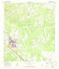
1964 Map of Boerne
USGS Topo · Published 1975About this map
Boerne serves as the focal point of this Texas Hill Country study, showing a period of transition as the town's urban footprint expands across Cibolo Creek. The landscape is defined by its characteristic hydrology and karst topography, most notably at Cascade Cavern and along the numerous tributary streams like Menger Creek and Frederick Creek. Significant local history is preserved through labels for the Herff Park Fairground and the Historical Marker near Malikoff Hill. Transportation and industry of the era are visible in the Southern Pacific railroad line and the numerous local Gravel Pits and Quarries that dot the limestone hills. Settlement patterns extend to outlying communities such as Kreutzberg and Walnut Grove, while rural life is marked by family landmarks like Phillips Cem and the Pleasant Valley Community Center.
Find a feature on this map
43 named features on this map. Tap any name to fly to it.
Don’t see what you’re looking for? This feature index may not catch every label — zoom into the map to look around manually.
Map Details
Editions of this 1964 Boerne Map
4 editions found

Other maps of this area

1953 · Otis Ridge
USGS Topo · 1:24,000

1953 · Van Raub
USGS Topo · 1:24,000

1954 · San Antonio
USGS Topo · 1:250,000

1956 · Comfort
USGS Topo · 1:62,500

1956 · Medina Lake
USGS Topo · 1:62,500

1957 · Boerne
USGS Topo · 1:62,500

1957 · San Antonio
USGS Topo · 1:250,000

1964 · Waring
USGS Topo · 1:24,000
1964 · Kendalia
USGS Topo · 1:24,000
1964 · Sisterdale
USGS Topo · 1:24,000