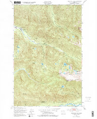
1950 Map of Bogachiel Peak
USGS Topo · Published 1977About this map
Sol Duc Hot Springs and the nearby Soleduck Ranger Sta serve as the northern anchors for this wilderness area within Olympic National Park. The landscape is defined by the high alpine hydrology of the Seven Lakes Basin, where a concentration of water bodies like Lunch Lake, Round Lake, and Morgenroth Lake sit perched beneath the Bogachiel High Divide. This watershed feeds the headwaters of the Soleduck River, the Bogachiel River, and the Hoh River.
Find a feature on this map
37 named features on this map. Tap any name to fly to it.
Don’t see what you’re looking for? This feature index may not catch every label — zoom into the map to look around manually.
Map Details
Editions of this 1950 Bogachiel Peak Map
4 editions found
Other maps of this area

1918 · Lake Crescent
USGS Topo · 1:62,500

1919 · Port Crescent
USGS Topo · 1:62,500

1922 · Lake Crescent
USGS Topo · 1:62,500

1935 · Mount Olympus
USGS Topo · 1:62,500

1939 · Mount Tom
USGS Topo · 1:62,500

1942 · Mount Olympus
USGS Topo · 1:62,500

1950 · Mount Muller
USGS Topo · 1:24,000

1950 · Lake Sutherland
USGS Topo · 1:24,000

1950 · Lake Crescent
USGS Topo · 1:24,000

1950 · Slide Peak
USGS Topo · 1:24,000