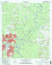
1982 Map of Bogalusa East
USGS Topo · Published 1982About this map
Bogalusa sits along the western banks of the Pearl River and Bogue Lusa Creek in the early 1980s, serving as a hub of industry and education for eastern Washington Parish. The city’s developed street grid, including White St and Redwood Ave, contrasts with the winding oxbow lakes of the river basin, such as Old Jail Lake, Gator Lake, and Horseshoe Lake. Educational institutions like the Sullivan Voc-Tech Inst and the High Sch anchor the community, while the George R Carr Memorial Airfield indicates the region’s mid-century transportation infrastructure.
Find a feature on this map
106 named features on this map. Tap any name to fly to it.
Don’t see what you’re looking for? This feature index may not catch every label — zoom into the map to look around manually.
Map Details
Editions of this 1982 Bogalusa East Map
2 editions found
Other maps of this area

1942 · Rio
USGS Topo · 1:31,680

1942 · Pools Bluff
USGS Topo · 1:31,680

1949 · Bogalusa East
USGS Topo · 1:31,680

1949 · Angie
USGS Topo · 1:31,680

1949 · Bogalusa West
USGS Topo · 1:31,680

1950 · Crains Creek
USGS Topo · 1:31,680

1953 · Mobile
USGS Topo · 1:250,000

1957 · Mobile
USGS Topo · 1:250,000

1958 · Picayune
USGS Topo · 1:62,500

1959 · Bogalusa
USGS Topo · 1:62,500