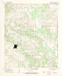
1969 Map of Boggy Depot
USGS Topo · Published 1971About this map
Boggy Depot serves as the focal point of this rural Oklahoma landscape, where the historical settlement is preserved within the Boggy Depot Recreation Area. The terrain is defined by the winding course of Clear Boggy Creek and its many tributaries, including Sandy Creek and Watson Creek. Local genealogy and community history are anchored by the Wilson Ch and several burial grounds, such as Wilson Cem and the Boggy Depot Cem.
Find a feature on this map
22 named features on this map. Tap any name to fly to it.
Don’t see what you’re looking for? This feature index may not catch every label — zoom into the map to look around manually.
Map Details
Editions of this 1969 Boggy Depot Map
2 editions found
Other maps of this area

1899 · Atoka
USGS Topo · 1:125,000

1900 · Atoka
USGS Topo · 1:125,000

1957 · Lehigh
USGS Topo · 1:24,000

1957 · Ardmore
USGS Topo · 1:250,000

1963 · Ardmore
USGS Topo · 1:250,000
1968 · Wapanucka South
USGS Topo · 1:24,000

1968 · Caddo NW
USGS Topo · 1:24,000
1969 · Boggy Depot
USGS Topo · 1:24,000

1969 · Caddo North
USGS Topo · 1:24,000
1969 · Tushka
USGS Topo · 1:24,000