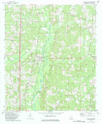
1972 Map of Bogue Chitto
USGS Topo · Published 1984About this map
The Bogue Chitto river corridor defines the central geography of this Lincoln County survey, appearing shortly after the 1971 aerial photogrammetric work. The Illinois Central Gulf railroad runs parallel to the river, anchoring established settlements like Norfield and Thayer. This landscape reflects a diverse economic pattern where traditional agriculture meets the industrial footprint of the Mallalieu Oil Field in the northeast and numerous scattered gravel operations. Community life is heavily documented through a dense network of country churches and burial grounds, including Springfield Ch, Bethel Ch, and the Price Cem. Notable landmarks such as the Water Tank in Bogue Chitto and the Substation Old further south provide specific points of reference for local historians. From the heights of Blueberry Hill to the banks of Moaks Creek, the map details a rural Mississippi landscape in a period of steady industrial and infrastructure development.
Find a feature on this map
39 named features on this map. Tap any name to fly to it.
Don’t see what you’re looking for? This feature index may not catch every label — zoom into the map to look around manually.
Map Details
Editions of this 1972 Bogue Chitto Map
2 editions found
Other maps of this area

1953 · Natchez
USGS Topo · 1:250,000

1956 · Natchez
USGS Topo · 1:250,000

1959 · Natchez
USGS Topo · 1:250,000

1972 · West Lincoln
USGS Topo · 1:24,000

1972 · Fair Oak Springs
USGS Topo · 1:24,000

1972 · Auburn
USGS Topo · 1:24,000

1972 · Ruth
USGS Topo · 1:24,000

1972 · Pricedale
USGS Topo · 1:24,000

1972 · Bogue Chitto
USGS Topo · 1:24,000

1972 · Brookhaven
USGS Topo · 1:24,000