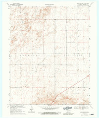
1969 Map of Boise City NW
USGS Topo · Published 1991About this map
The Beaver River winds through the southern landscape of this Oklahoma Panhandle survey, a region defined by its expansive topography and the section-line grid of the High Plains. Tracing the border between the Wheeless and Cleveland districts, the map reveals a terrain primarily dedicated to water extraction and ranching. Numerous wells are distributed across the township blocks, highlighting the critical reliance on groundwater in this arid environment during the late 1960s. The dense contour lines near the river valley contrast with the flatter upland plateaus, providing a clear picture of the land's drainage patterns and the subtle changes in elevation that dictated local agricultural and settlement boundaries.
Find a feature on this map
3 named features on this map. Tap any name to fly to it.
Don’t see what you’re looking for? This feature index may not catch every label — zoom into the map to look around manually.
Map Details
Editions of this 1969 Boise City NW Map
3 editions found
Other maps of this area

1954 · Dalhart
USGS Topo · 1:250,000

1958 · Dalhart
USGS Topo · 1:250,000

1962 · Dalhart
USGS Topo · 1:250,000

1969 · Boise City
USGS Topo · 1:24,000

1969 · Boise City NW
USGS Topo · 1:24,000

1969 · Boise City SW
USGS Topo · 1:24,000

1969 · Felt
USGS Topo · 1:24,000

1969 · Flagg Springs
USGS Topo · 1:24,000

1969 · Boise City SE
USGS Topo · 1:24,000

1969 · Felt NE
USGS Topo · 1:24,000