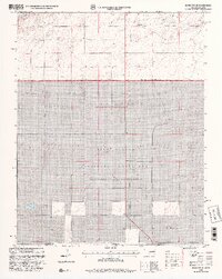
1998 Map of Boise City SE
USGS Topo · Published 2001About this map
The Rita Blanca National Grassland dominates this high plains landscape along the state line, where the panhandles of Oklahoma and Texas meet. Administered as part of the Cibola National Forest, this territory reflects the mid-century transition of sub-marginal farmland back into federally managed conservation areas. The map reveals a sparse, utilitarian settlement pattern defined by land divisions such as Cleveland and the occasional well, indicating the critical role of groundwater for livestock and survival in this arid environment. A single Gas Pipeline cuts a diagonal path across the terrain, representing the region's contribution to the broader energy infrastructure of the Southern Plains during the late 20th century.
Find a feature on this map
6 named features on this map. Tap any name to fly to it.
Don’t see what you’re looking for? This feature index may not catch every label — zoom into the map to look around manually.
Map Details
Editions of this 1998 Boise City SE Map
2 editions found
Other maps of this area

1954 · Dalhart
USGS Topo · 1:250,000

1958 · Dalhart
USGS Topo · 1:250,000

1962 · Dalhart
USGS Topo · 1:250,000

1969 · Boise City
USGS Topo · 1:24,000

1969 · Boise City NW
USGS Topo · 1:24,000

1969 · Boise City SW
USGS Topo · 1:24,000

1969 · Boise City SE
USGS Topo · 1:24,000

1971 · Conrad NW
USGS Topo · 1:24,000

1971 · Conrad SW
USGS Topo · 1:24,000

1973 · Stratford 2 NW
USGS Topo · 1:24,000