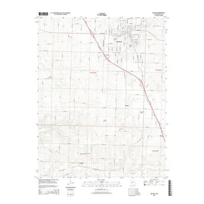
2015 Map of Bolivar
USGS Topo · Published 2015About this map
Bolivar serves as the focal point of this 2015 survey, revealing a landscape defined by its institutional and agrarian character. The campus of Southwest Baptist University occupies a significant portion of the city's south side, while long-established burial grounds like City Cemetery and Greenwood Cemetery offer clear markers for genealogical research. To the south, the terrain opens into a network of small settlements including Karlin, Slagle, and Wishart, each linked by a grid of rural roads and defined by the winding paths of Tommie Creek and Slagle Creek. The presence of the Cherokee Airpark south of the city center highlights the mix of local infrastructure and private aviation in this part of Polk County. Further out, small family-named landmarks like Hensley Cemetery and Spencer Cemetery remain as quiet sentinels of the region's early rural heritage.
Find a feature on this map
110 named features on this map. Tap any name to fly to it.
Don’t see what you’re looking for? This feature index may not catch every label — zoom into the map to look around manually.
Map Details
Editions of this 2015 Bolivar Map
This is the sole edition of this map. No revisions or reprints were ever made.
Other maps of this area

1884 · Springfield
USGS Topo · 1:125,000

1884 · Bolivar
USGS Topo · 1:125,000

1886 · Stockton
USGS Topo · 1:125,000

1886 · Greenfield
USGS Topo · 1:125,000

1886 · Springfield
USGS Topo · 1:125,000

1888 · Greenfield
USGS Topo · 1:125,000

1892 · Bolivar
USGS Topo · 1:125,000

1950 · Polk
USGS Topo · 1:24,000

1950 · Cliquot
USGS Topo · 1:24,000
1951 · Cliquot
USGS Topo · 1:24,000