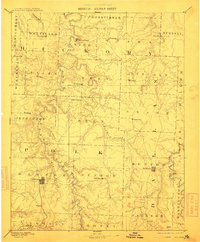
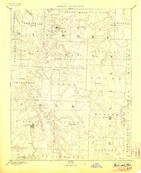
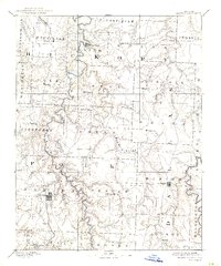
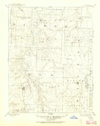
1892 Map of Bolivar
USGS Topo · Published 1912About this map
Bolivar and Buffalo anchor this 1880s survey of the Ozark foothills, where the early settlement pattern is defined by the winding drainages of the Pomme De Terre River and the Niangua River. This reconnaissance map documents the region before modern highway networks, showing a landscape dotted with small post offices and agricultural hubs like Wheatland, Hermitage, and Urbana. The prevalence of small-scale infrastructure, such as Parks Mill on the Little Niangua River, underscores a rural economy dependent on local water power and mill sites.
Find a feature on this map
58 named features on this map. Tap any name to fly to it.
Don’t see what you’re looking for? This feature index may not catch every label — zoom into the map to look around manually.
Map Details
Editions of this 1892 Bolivar Map
5 editions found
Other maps of this area

1884 · Springfield
USGS Topo · 1:125,000

1884 · Bolivar
USGS Topo · 1:125,000

1886 · Stockton
USGS Topo · 1:125,000

1886 · Greenfield
USGS Topo · 1:125,000

1886 · Springfield
USGS Topo · 1:125,000

1887 · Clinton
USGS Topo · 1:125,000

1887 · Warsaw
USGS Topo · 1:125,000

1888 · Versailles
USGS Topo · 1:125,000

1888 · Greenfield
USGS Topo · 1:125,000

1892 · Bolivar
USGS Topo · 1:125,000