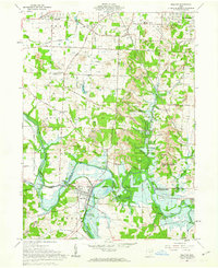
1961 Map of Bolivar
USGS Topo · Published 1963About this map
The Greenville Treaty Line and the Geographers Line converge in this 1961 survey, marking a significant historical intersection of land divisions in eastern Ohio. The Tuscarawas River carves through the southern landscape, where the Ohio Canal remains a visible ghost of earlier nineteenth-century commerce near Bolivar. This era shows the region under the management of the Muskingum Watershed Conservancy District, with the Bolivar Dam and its associated inundation zones protecting the valley. Local history is deeply etched into the hills of Perry and Bethlehem townships, evidenced by family-named landmarks like Shepler Cem and Meiserheimer Cem. Rural life is anchored by small community centers such as Richville and North Industry, while the extraction economy is represented by numerous Strip Mines and gas wells scattered across the terrain, particularly near Riceford.
Find a feature on this map
61 named features on this map. Tap any name to fly to it.
Don’t see what you’re looking for? This feature index may not catch every label — zoom into the map to look around manually.
Map Details
Editions of this 1961 Bolivar Map
2 editions found
Other maps of this area

1901 · Massillon
USGS Topo · 1:62,500

1901 · Canton
USGS Topo · 1:62,500

1903 · Massillon
USGS Topo · 1:62,500

1903 · Canton
USGS Topo · 1:62,500

1912 · Dover
USGS Topo · 1:62,500

1914 · Navarre
USGS Topo · 1:62,500

1944 · Navarre
USGS Topo · 1:62,500

1944 · Dover
USGS Topo · 1:62,500

1951 · Canton
USGS Topo · 1:250,000

1951 · Bolivar
USGS Topo · 1:24,000